Image
Légende
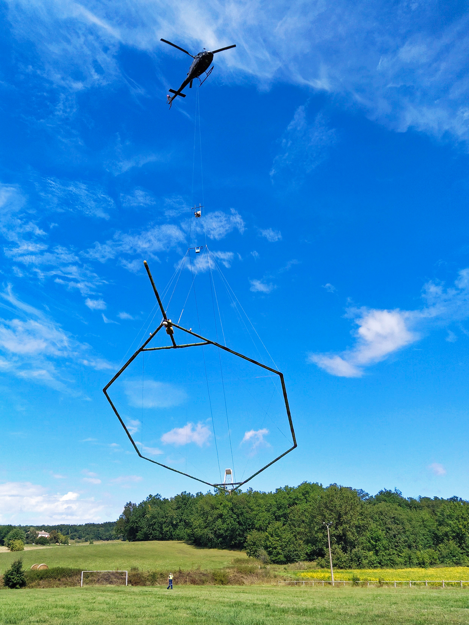
Skytem heliborne survey system (for electromagnetic and magnetic measurements) used for the airborne geophysics programme in the western Massif Central. © BRGM - A. Raingeard
Geology and knowledge of the subsurface
Skytem heliborne survey system (for electromagnetic and magnetic measurements) used for the airborne geophysics programme in the western Massif Central. © BRGM - A. Raingeard
This type of airborne campaign is quite frequently carried out abroad and in French Overseas Territories, but is rare in metropolitan France. Commissioned by the Ministry of Ecological Transition, BRGM has been conducting a programme to collect geological data using airborne measurement systems in the western part of the Massif Central (excluding urban areas) since the summer of 2022. Carried out by plane over hilly areas and by helicopter over the more rugged terrain, the surveys combine three geophysical measurement methods, which were successfully tested during the AérOvergne campaign carried out in 2020 on the Puys mountain chain: gamma-spectrometry, electromagnetism and magnetism. This makes it possible to obtain data ranging from the near-surface to a depth of several hundred metres.
“The advantage of airborne surveys is that they are quick and provide continuous, uniform coverage of the area concerned, regardless of what the land is used for and the nature of the terrain, while having no impact on the environment or human health,” says Guillaume Martelet.
The programme aims to map the specific physico-chemical properties of soils and rocks. It is supplemented by a geochemical analysis campaign of stream sediments – a first in metropolitan France since the mining inventory carried out by BRGM was suspended in 1991! “While airborne surveys can be used to quantify the potassium, uranium and thorium content in the subsurface, geochemical sampling on the ground can be used to simultaneously analyse 49 chemical elements, including all the critical metals that are useful for the energy transition,” explains Matthieu Chevillard. The laboratory analysis of these samples has established the regional geochemical background and determined the location of potentially interesting areas for different types of mineral resources, in particular certain critical metals (tungsten, antimony, lithium, etc.). The geochemistry of the zone covered by two 1:50,000-scale geological maps, for the regions of Limoges and Rochechouart in the Haute-Vienne département (which were not surveyed during the mining inventory), was therefore studied, to complement the geophysical survey.
The geophysical survey campaigns carried out in 2022 targeted an area stretching from Limoges and Gannat in the north to Castres in the south, passing through Figeac, Villefranche-de-Rouergue and Langeac.
By the end of the programme, towards the end of 2024, the entire western Massif Central, from Limagne to the Aquitaine and Paris basins, will have been surveyed. The airborne geophysical data are compiled in annual reports submitted to the French Ministry of Ecological Transition. They also undergo advanced processing by BRGM, using specific software, and are cross-referenced with other geological knowledge, primarily surface geochemical data collected during prospecting campaigns, in order to better characterise the mining potential of the Massif Central.


In addition, the data will also be used for a hydrogeological programme in 2023. “In line with what has been done overseas in recent years, we will use the same data but in a different way, in order to improve our knowledge and management of water resources in the areas investigated,” says Guillaume Martelet, while adding that: “Geophysical survey techniques, historically developed for mining purposes, are now more widely used by BRGM to assess many different characteristics of the subsurface.”
In this way, the data (which are open to the public) from this campaign in the Massif Central will also be used for BRGM’s work in the framework of the (PEPR)1 for the Subsurface. The data will also be available to teams based in the regions to assist local stakeholders in decision-making, in particular local authorities who are interested in evaluating the potential of the region’s geothermal resources, assessing hazards (earthquakes, ground movement, shrinkage-swelling of clay) or planning development work (tunnels, dams, geological storage, etc.). “The data can be used in every area of the geosciences and exploited according to the different needs of stakeholders, from academic research to industrial applications,” says Guillaume Martelet.
(1) Priority research programmes and equipment.
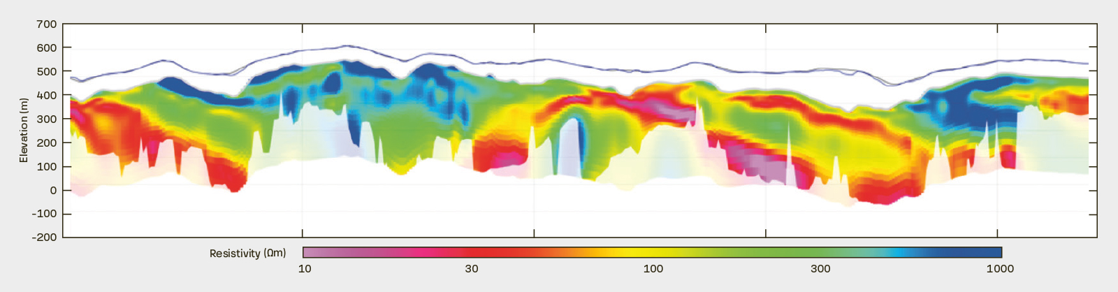
Example of the subsurface resistivity profile obtained by inversion of airborne electromagnetic data acquired along a flight path; here in the northern part of the Montagne Noire. © BRGM - G. Martelet