


Image
Légende
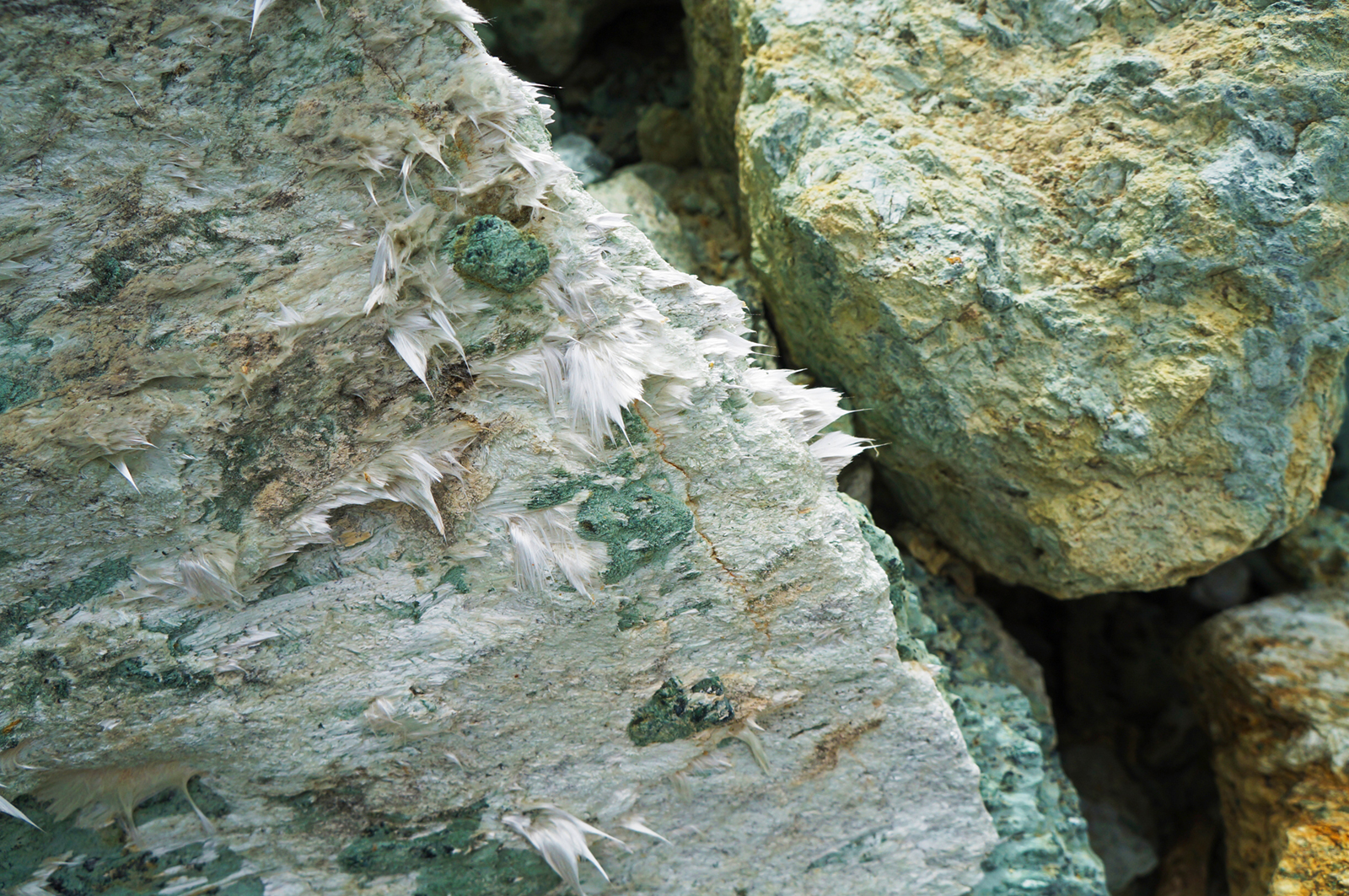
Photo of actinolite asbestos, Canelle, Haute-Corse. © BRGM - C. Coutin
Geology and knowledge of the subsurface
Since 2010, BRGM has been working with the Corsica Environment Office and the Corsica Regional Directorate for the Environment, Planning and Housing (Dreal), on a series of projects to identify the asbestos-bearing potential of municipalities in Haute-Corse. These projects use maps on a scale of 1:5,000 to show the likely presence of asbestos in the natural environment. This task is scheduled to reach completion in 2023, with the publication of the last maps, covering an area of 4,870 hectares in the main investigation zones of 73 municipalities. BRGM will also set up a dedicated website: amiante-corsica.brgm.fr
Photo of actinolite asbestos, Canelle, Haute-Corse. © BRGM - C. Coutin
To coincide with the Biennale of Architecture and Landscaping, which took place in Versailles between May and July 2022, the Paris Regional Institute asked BRGM to provide a simplified geological cross-section of the Paris region, for educational purposes. Based primarily on drilling data and geological maps and applying a scale of 1:50,000, the cross-section covers an area of just over 180 km in length. Using an exaggerated vertical scale, it illustrates the geometry, diversity and major geological features of the Cenozoic core of the Paris Basin, such as the large sedimentary units with their wealth of resources, and the anticlines and synclines that have constrained the evolution of the basin for a period of at least 66 million years.
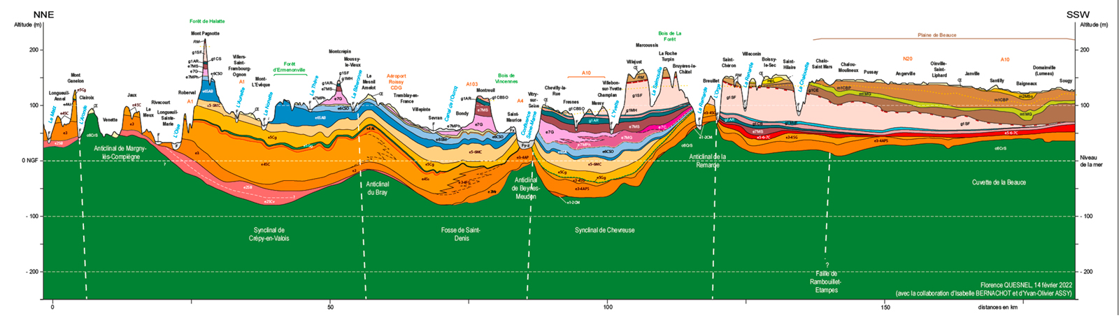
Simplified geological cross-section of the Cenozoic core of the Paris Basin. © BRGM
On 10 March 2022, BRGM was questioned by the National Commission for the Assessment of Research and Studies on the Management of Radioactive Materials and Waste at the Maison de la Chimie in Paris. Its presentation concerned the multidisciplinary and multi-scale study programme on the karstic aquifers of Barrois limestone in eastern France. This shallow-lying area could become the chosen location for the surface installations of Cigéo, the future deep geological repository for nuclear waste. This multi-year programme is conducted in partnership with Andra, the University of Lorraine and the Centre for Hydrogeology and Geothermics in Neuchâtel.
Three papers written as part of the ANR Coyotes project (COmoros & maYotte: vOlcanism, TEctonics and Seismicity) were published in the journal “Comptes Rendus Géoscience” in 2022. Thinon et al. provide a new map of the geological structures around the Comoros archipelago, where two large recent volcanic provinces have been discovered. Masquelet et al. show that the new Fani Maoré underwater volcano is sitting on an older basaltic layer, which is itself positioned on a thick layer of sediment. The construction of Mayotte is thought to have started 27 million years ago, with the volcanic eruption of 2018-2019 occurring after some 4.6 million years of calm. Using heat-flow analysis, Rolandone et al. were able to eliminate the hotspot hypothesis in establishing the origins of the volcano.
Thinon et al. Volcanism and tectonics unveiled in the Comoros Archipelago between Africa and Madagascar Comptes Rendus. Géoscience, Tome 354 (2022) no. S2, pp. 7-34. doi : 10.5802/crgeos 159.
Masquelet et al. The East-Mayotte new volcano in the Comoros Archipelago: structure and timing of magmatic phases inferred from seismic reflection data. Comptes Rendus. Géoscience, Tome 354 (2022) no. S2, pp. 65-79. doi : 10.5802/crgeos.154.
Rolandone et al. Heat flow measurements in the Northern Mozambique Channel. Comptes Rendus. Géoscience, Tome 354 (2022) no. S2, pp. 35-46. doi : 10.5802/crgeos.130
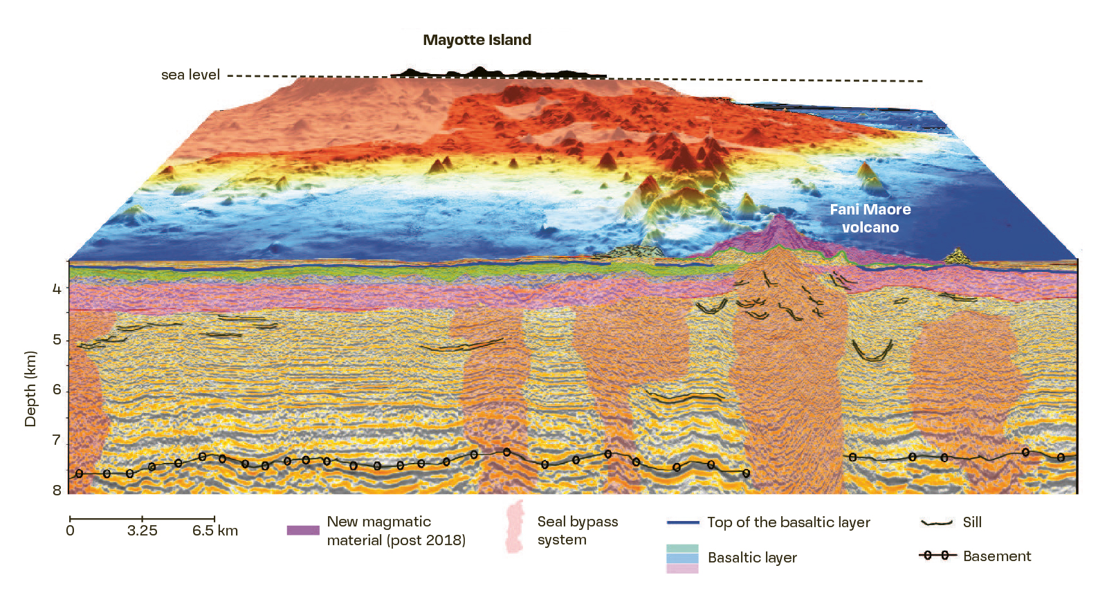
3D block diagram of the maritime domain showing the Fani Maoré volcano 50 km east of Mayotte and the underlying bedrock. The seismic profile analysed (MAOR21D01) is converted into depth (Masquelet et al., 2022). © BRGM
As part of their R&D activities and in order to address technical and operational challenges, BRGM and the French National Agency for Radioactive Waste Management (Andra) need a reliable reference code for modelling two-phase transfers (liquid and gas) in underground facilities and their enclosures. They have therefore started a new project to further develop the ComPASS code and apply it, amongst other objectives, to the study of radioactive waste storage and disposal, as well as to flow simulation within a sedimentary basin, using a realistic and detailed geological model. This collaboration will last at least until the end of 2023.


