Image
Légende
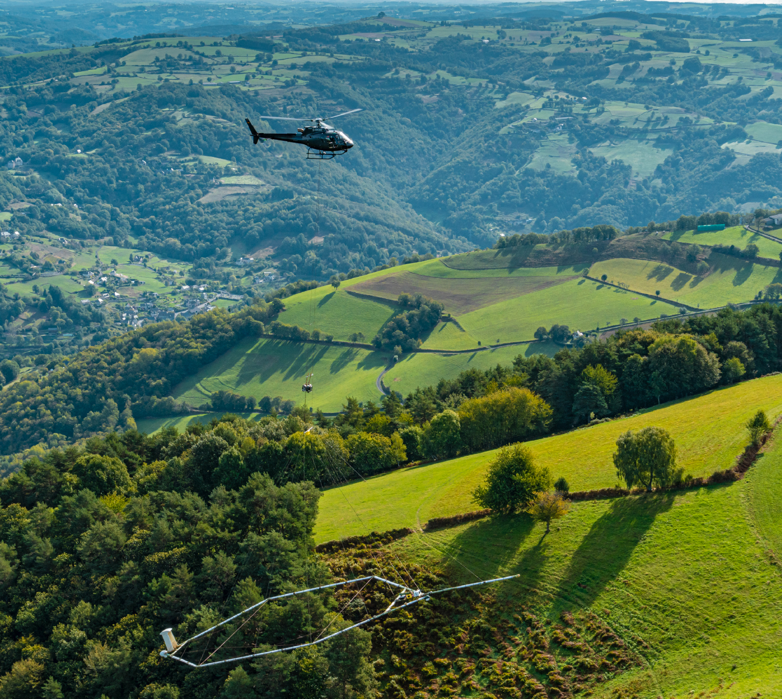
More than 90,000 kilometres were covered in 2024 as part of airborne geophysical surveys in mainland France, for example here in the Massif Central. © Alexandre Magnan
Geology and subsurface modelling
More than 90,000 kilometres were covered in 2024 as part of airborne geophysical surveys in mainland France, for example here in the Massif Central. © Alexandre Magnan
In 2024, BRGM collected geophysical data using airborne sensors in mainland France for the third year running. “Following the heliborne campaigns carried out in the French Overseas Territories in the 2010s, the data was used for many different applications. This highlighted the value of the subsurface information acquired during such campaigns, which can be used for such a variety of purposes,” explains Guillaume Martelet. The three areas concerned by the campaigns conducted last year had either never been covered previously, or only limited information was available. The areas covered were the western Massif Central (programme underway since 2022), the Vosges and the Monts du Lyonnais. The campaigns were commissioned by the Directorate-General for Planning, Housing and Nature (DGALN) at the French Ministry for Ecological Transition. A fourth campaign was carried out on the island of Rodrigues in the Indian Ocean, on behalf of the French Development Agency (AFD) and the Republic of Mauritius.
More than 90,000 kilometres were covered by plane or helicopter, depending on the terrain – rolling hills or more abrupt terrain – in order to collect data based on three geophysical methods: magnetism, electromagnetism and gamma spectrometry. “Airborne surveys are the most efficient solution in terms of coverage, time and cost,” says Pierre-Alexandre Reninger. “Over a relatively short period of time, you can acquire large quantities of high-resolution data over large areas. The data acquisition is continuous and homogeneous and there are no constraints linked to land use or accessibility.”
The geophysical data is then processed by BRGM using specific software, in order to make the data usable. “We are the only organisation in France that masters the entire knowledge production chain, from preparing and planning the airborne measurements to monitoring, processing and exploiting the data collected,” says Aurélie Peyrefitte.
For metropolitan France, this “ready-to-interpret” data is public and made available to all stakeholders involved in issues relating to the subsurface by the French Ministry for Ecological Transition, via the data.gouv.fr website. And that includes BRGM itself, which is responsible for updating the National Inventory of French Subsurface Mineral Resources, for which it is responsible, and the “Subsurface: a Common Good” Priority Research and Equipment Programme (PEPR), which it co-manages with CNRS. In addition to improving geological knowledge, the data can also be used to help manage water resources and study the feasibility of deep geothermal energy or the phenomenon of shrinking-swelling clay-rich ground. Equally, it can be used to help assess seismic hazards or ground movements and to evaluate the feasibility of regional planning developments (tunnels, dams, etc.) or geological storage facilities.
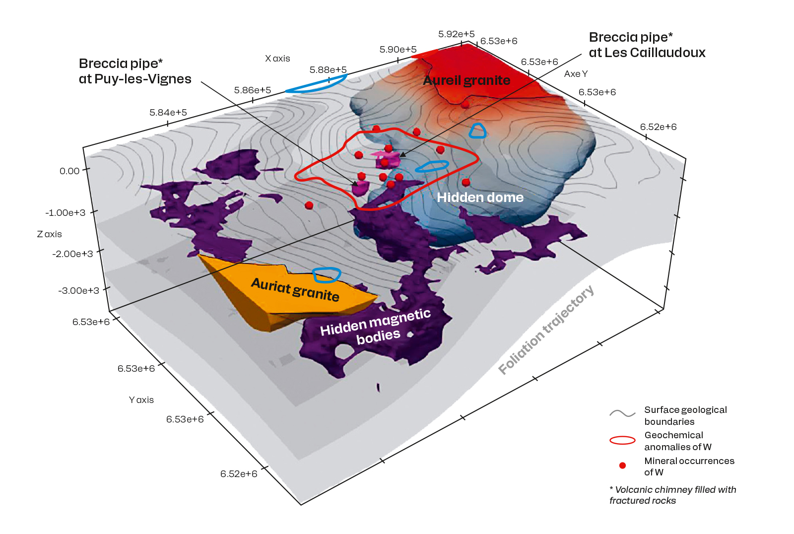
3D geological model of the Puy-les-Vignes district (87) based on the combined interpretation of geological field data and airborne geophysics. © BRGM
“This infrastructure data provides an unrivalled, multi-thematic characterisation of the subsurface, ranging from the surface to several kilometres below it depending on the type of measurement. In the years to come, this information will be useful in all areas of geosciences and at every level, from academic research to industrial applications and right down to very local levels,” explains Anne Raingeard.
The data is already being used in Rodrigues for the purposes of a groundwater study. “The analysis of the geophysical data collected, supplemented by surveys on the ground, will help us model how the island’s hydrogeological system works,” explains Bertrand Aunay. “The aim is to characterise the aquifers and quantify the groundwater potential.” This will help determine how the different water resources can be used to meet all the various needs of local residents.