


Image
Légende
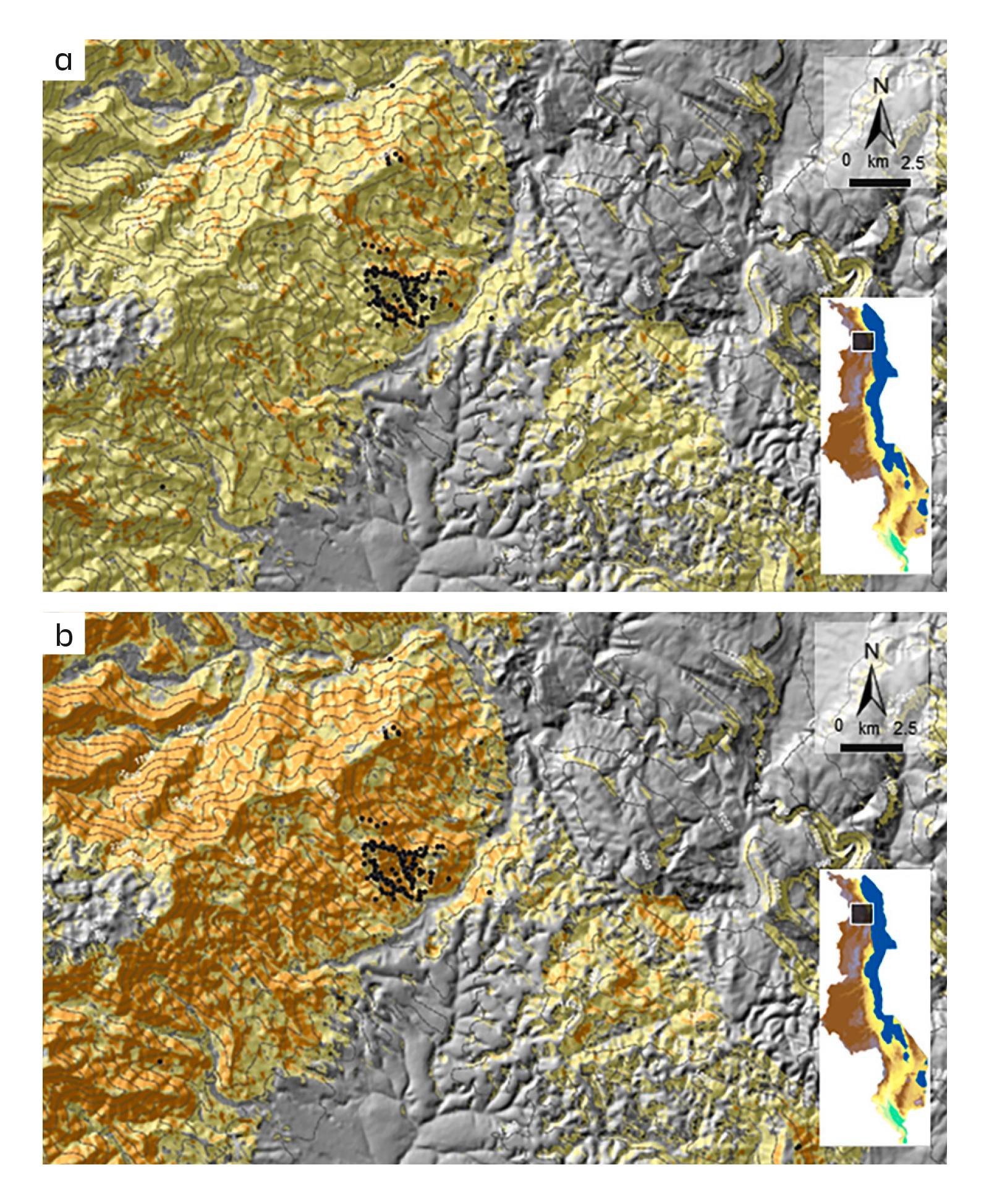
Landslide hazard maps for return periods of 10 years (a) and 50 years (b), for intense cyclone-type weather events, such as Idai in 2019. © BRGM
Risks linked to the ground and subsurface
BRGM and the Malawi Geological Survey collaborated on a project to map landslide hazards in the country. The first step was to improve the accuracy of the inventory of these events and to collect relevant information. These data were then used to conduct susceptibility analyses and to calculate the probability of landslide reactivation over six return periods (from 1 to 100 years) following severe weather events. This made it possible to create hazard maps for different types of phenomena. A number of spatio-temporal scenarios were developed at a national level.
Landslide hazard maps for return periods of 10 years (a) and 50 years (b), for intense cyclone-type weather events, such as Idai in 2019. © BRGM
BRGM has developed a rapid response tool for use in the event of an earthquake. Currently covering the French West Indies and Mayotte, SEISAid is able to reliably estimate the number of damaged buildings and victims to take care of in under 20 minutes. This information is provided in the form of reports sent out automatically by e-mail and text message. In December 2024, BRGM signed an agreement with the French Ministry of the Interior to upgrade SEISAid from a scientific demonstrator to a robust, scalable operational tool.
The database of pedogeochemical profiles of anthropogenic soils (FPGA) is a valuable decision-support tool for urban planners. Used in soil surveys or diagnoses it allows them to identify compatible recipient sites for recycling excavated soil. The BDSolU urban soil analysis database is used to store the results of various projects. In 2024, the first FPGA statistics and baselines were made available to the public for the geographical areas most densely represented in the database. The initial FGU project (Fonds pédoGéochimiques Urbains – Urban soil pedogeochemical backgrounds), co-funded by Ademe and BRGM, provided the basis for both BDSolU – now one of the programmes of the scientific interest group GIS Sol – and this database of pedogeochemical backgrounds.
BRGM co-supervised a thesis, defended in 2024, showing that the environmental harm caused by modern warfare continues to leave a lasting impact on soil and water. Focusing primarily on the western front of WWI and the area immediately behind it, this cross-disciplinary research work analyses the pollution caused by the war, which is still present today. It also looks at the inter-war period and the industrial processing of explosive remnants on a scale never seen before.
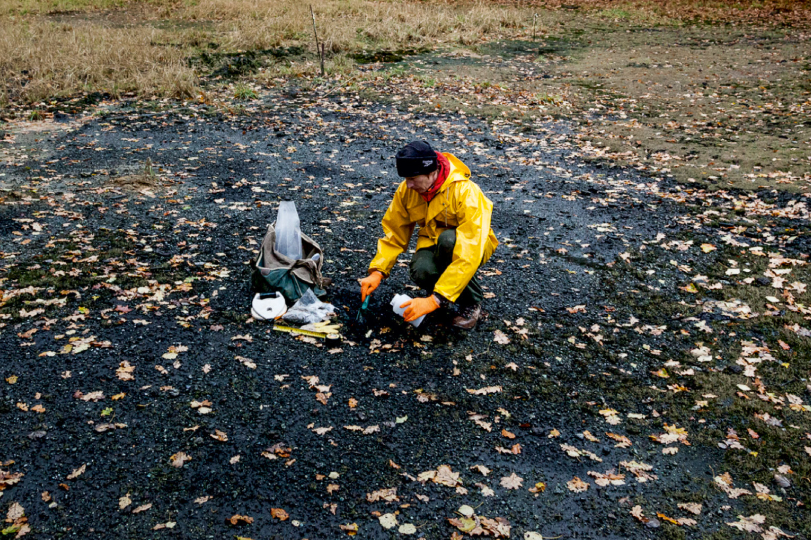
Sampling residues from the burning of former German chemical munitions at the site known as la place à gaz (gas place) in the Spincourt forest, in the Meuse department of eastern France. © BRGM
Thibault Laigre won the 2024 BRGM Thesis Prize for a study highlighting the role played by coastal ecosystems in reducing the impact of storms on Caribbean islands. Co-supervised by BRGM as part of the Interreg CaribCoast project, the thesis combines field observations, video analysis and numerical simulations. It has been discussed in three scientific publications and also contributed to the development of a methodological guide for rational coastline management. Plans are underway for implementation in Guadeloupe and French Polynesia.
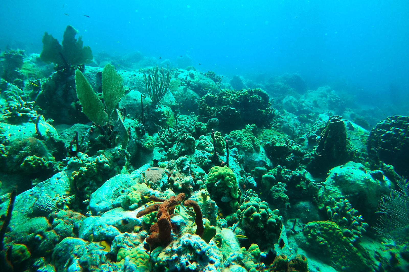
Coral reefs and upper beach vegetation are helping to reduce the impact of storms along the coastlines of Caribbean islands. © BRGM
Working with ANSES and the analysis laboratory of the Drôme department, BRGM co-authored an article entitled “Microwave-enhanced thermal removal of organochlorine pesticide (chlordecone) from contaminated soils”, published in the journal Chemosphere. This paper describes experimental results that demonstrate the efficiency of microwave-enhanced thermal treatment in decontaminating soil polluted by chlordecone. Concentrations can be reduced by up to 90%, a far higher rate than with previously known techniques such as in situ chemical reduction (for a decrease of between 2% and 40%). This work could provide the basis for a research project to specify the performance and fields of application of this microwave-enhanced technique and study its environmental consequences.
Progress has been made recently in characterising the factors involved in the occurrence of clay shrinkage and swelling, following a thesis defended in 2024 and co-supervised by BRGM, Météo-France and the Caisse Centrale de Réassurance (CCR). This has made it possible to better quantify the overall number of damage claims statistically. A Yearly Drought Magnitude Index (YDMI) was defined to identify the conditions likely to lead to shrinkage. This indicator was then calculated for the past period of 2000-2022 and for the future period up to 2065, based on different climate scenarios in France. The YDMI for each year was then cross-referenced, alongside three qualitative criteria for soil susceptibility to shrinkage and swelling established by BRGM (mineralogy, lithology, geotechnical properties), with insurance data, to train a model for predicting the number of damage claims at national level.
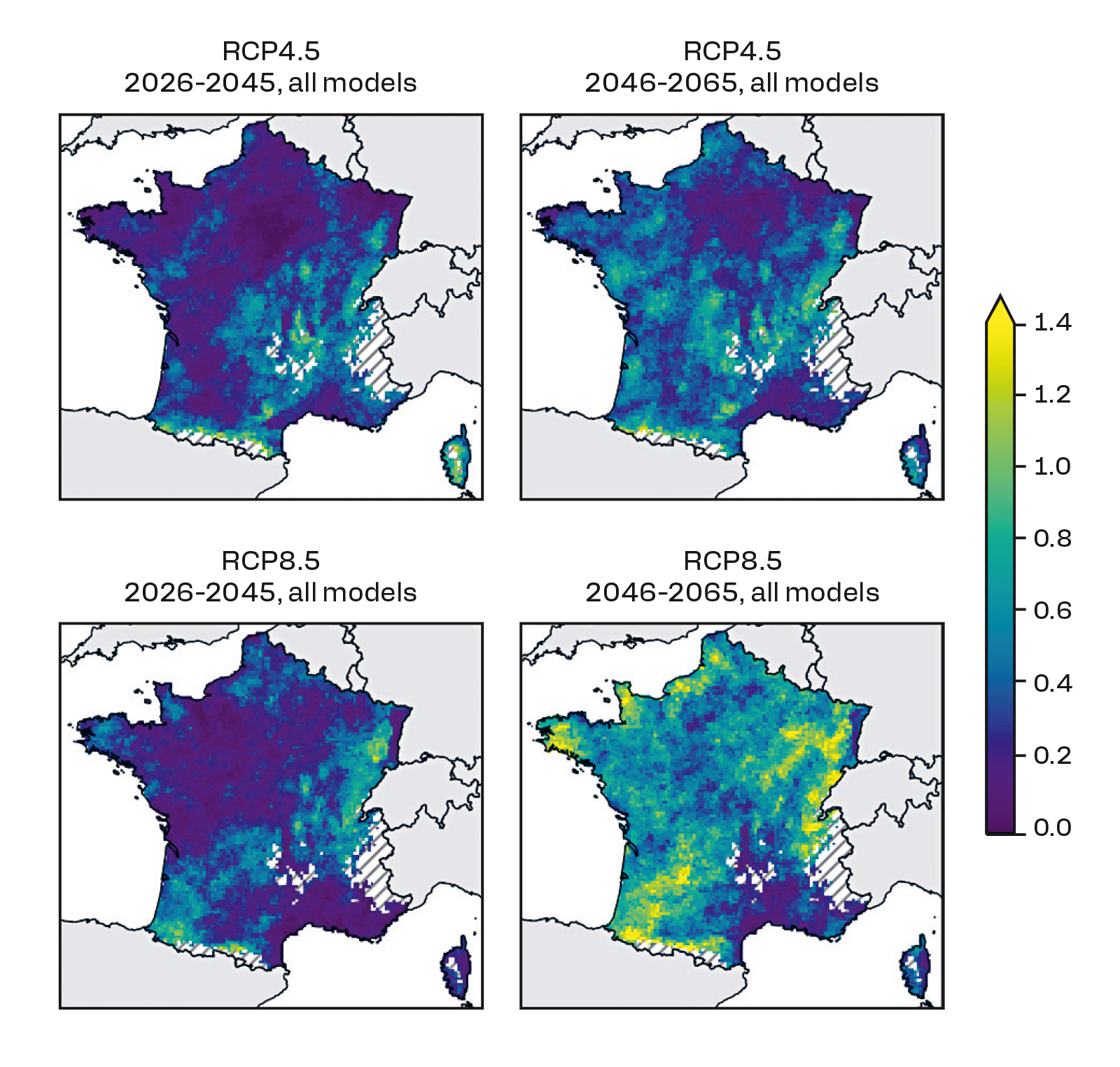
Regardless of the climate scenario adopted, projections show that the frequency and intensity of droughts leading to clay shrinkage and swelling are set to increase. © BRGM
Commissioned by the DREAL of Hauts-de-France in July 2024, BRGM intervened rapidly to secure the Saint-Roch shaft in Vieux-Condé, in the Nord region. After major work to clear the area surrounding the structure, a 3D scan managed to establish that 135m3 of backfill had been lost, probably carried away by the water discharged into the shaft from a previously unidentified aqueduct. Initial infilling was carried out in November using expanded clay balls. In addition, cement slurry was injected in December to stabilise the concrete slab. An operation to reinforce the ground through injection is planned during the first half of 2025 to ensure the safety of the shaft-head, while maintaining the aqueduct (whose route has now been fully determined) in service.
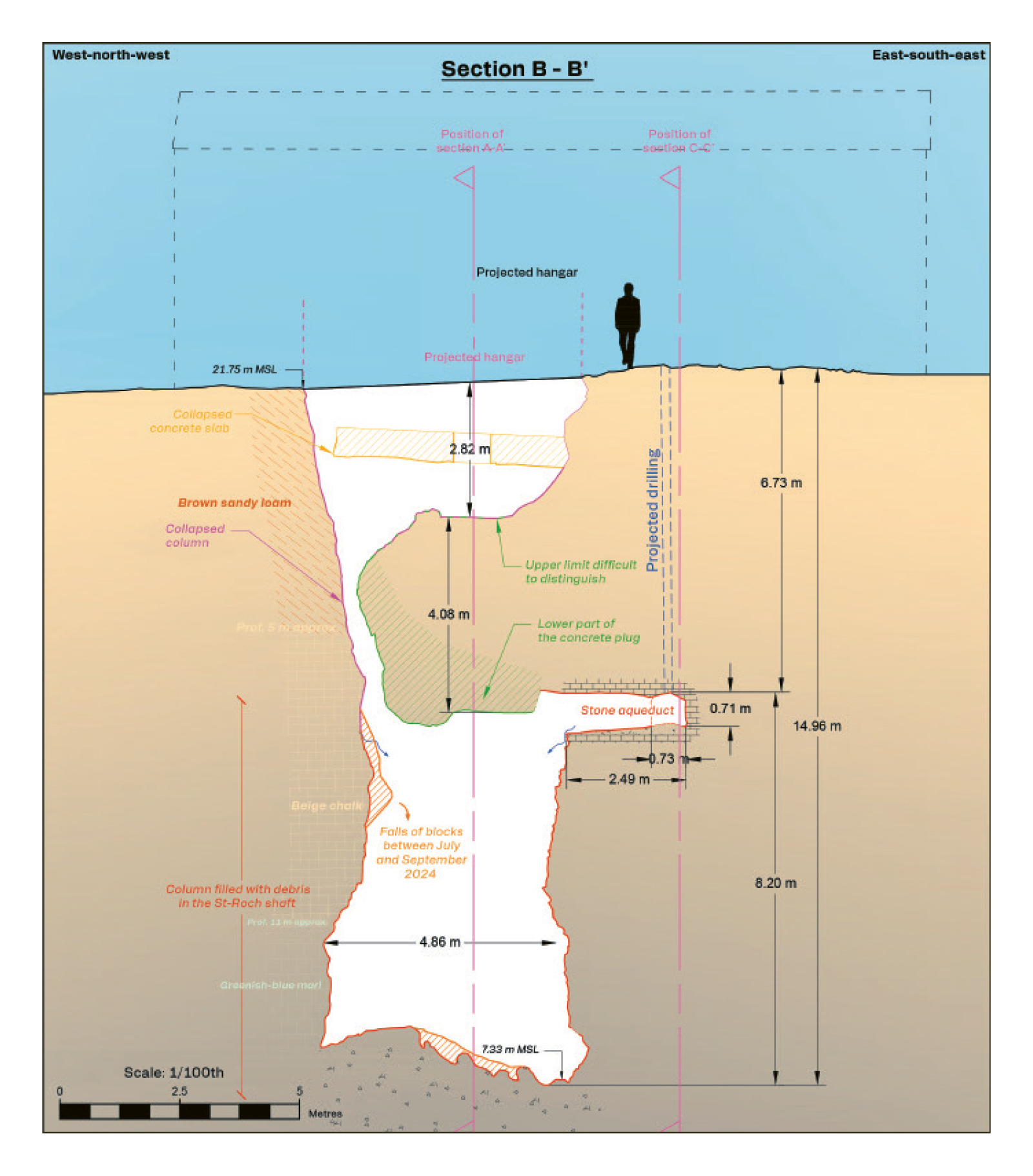
Representation of the Saint-Roch shaft in Vieux-Condé (59), illustrating the volumes of backfill material lost into the column. © IGECAV
In 2024, BRGM completed the work to ensure the safety of six former mining structures (shafts, chimneys, galleries) on the Fournial mine in Molèdes, Cantal, using solutions adapted to their complex configuration. For example, to repair a gallery that passes under a road, tunnelling techniques were used to create the by-pass structure. At the same time, a helicopter was used to deliver and remove the site equipment needed to work on a shaft that was inaccessible to land vehicles. Finally, to protect the habitat of the bats living in the structures, the work was carried out according to a specific schedule, to ensure the animals could continue to come and go.
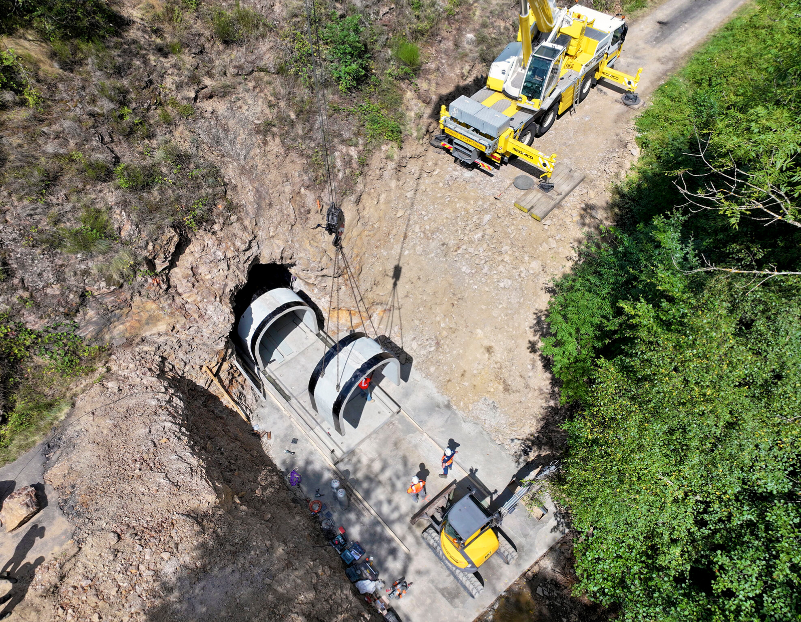
Tunnelling techniques were used to repair a gallery passing under the RD 9 departmental road in Molèdes (Cantal). © BRGM - DPSM
Certain slag heaps around former coal extraction sites are monitored annually by BRGM because of potentially dangerous heating phenomena. In Saint-Étienne, in the Loire département, the Couriot slag heaps have been monitored by an experimental drone equipped with a thermal camera since 2024. These airborne surveys provide accurate orthophotographs, each pixel of which contains an estimate of the surface temperature. Carrying out these measurements repeatedly, year after year, will enable us to monitor heat increases in areas that are already known for this phenomenon, while also helping to identify new ones. Temperature measurements that are currently carried out on foot, and which are risky for the staff involved, could be partly replaced by airborne campaigns in the future.
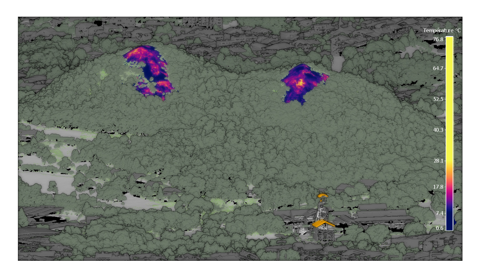
The thermal orthophotographs of the Couriot slag heap in Saint-Étienne (Loire) provide an estimate of the surface temperature. © BRGM

