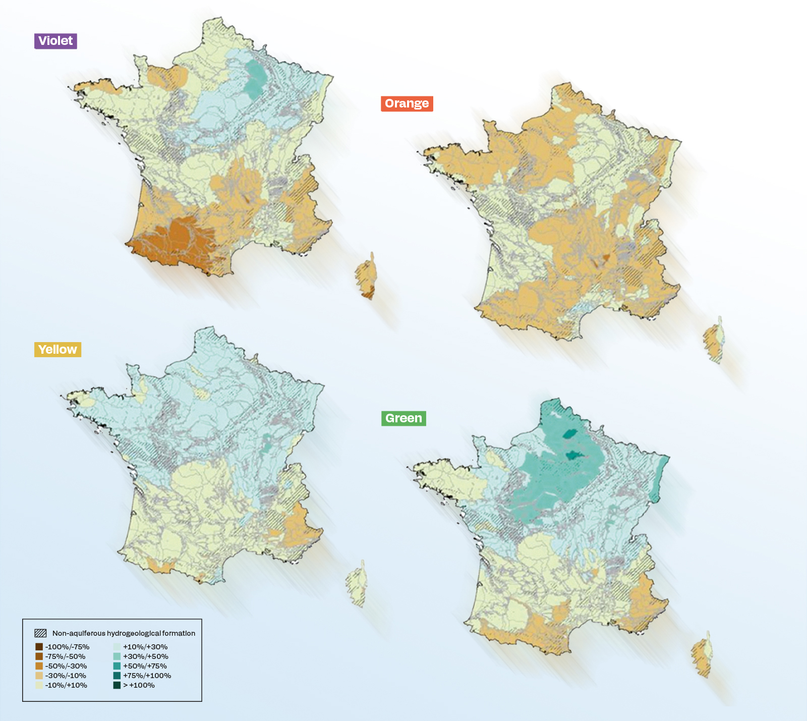
Légende
Relative changes in cumulative annual recharge at the end of the century (from 2070 to 2099) compared with the 1976-2005 period, for the four Explore2 study narratives:
- Green: significant warming and increase in precipitation;
- Yellow: relatively little change in the future;
- Orange: substantial warming and annual dessication;
- Violet: substantial warming and sharp seasonal contrasts in precipitation.
© Lanini et al., 2024
Periods of drought, severe flooding, etc. – climate change is unquestionably affecting the weather, albeit in different ways in different parts of the world. The impact on river systems is complex on the scale of France. Predicting changes in water resources over the coming decades is all the more difficult given the large number of climate models.
Updating is possible and relevant
In 2021, the French National Agriculture, Food and Environmental Research Institute (INRAE) and the International Office for Water (OiEau) launched the Explore2 project, which involves projecting changes in water resources throughout the 21st century in mainland France. Funded by the Ministry for Ecological Transition and the French Office for Biodiversity, this study follows on from Explore 2070, which between 2010 and 2012 produced initial projections for the period from 2050 to 2070 in mainland France and the French overseas territories. Over the last ten years, climate models have become considerably more refined, making it possible and relevant to update the hydro system projections in France for the period from now until 2100 on the basis of the latest climate scenarios published by the IPCC. Explore2 also aimed to help regional stakeholders understand and use these results to adapt their water resource management strategies.
A number of French research bodies (Météo France, BRGM, ENS-PSL, Sorbonne University, IRD, CNRS and EDF) have joined forces to form a scientific consortium coordinated by INRAE. Each of them focused on a particular issue in a coordinated methodological framework: climate projections, hydrological projections for surface water and groundwater, calculation of uncertainties, scenarios for the occurrence of extreme hydrological events, dissemination and use of the results, etc. “BRGM was called upon in particular to model the groundwater aspects of the water cycle,” explains Jean-Pierre Vergnes. “This mainly relates to changes in groundwater levels, but also groundwater recharge, i.e. the water that seeps underground to potentially replenish aquifers.”
Three emission scenarios
The BRGM researchers used several regional climate models produced by Météo France, themselves based on three greenhouse gas emission scenarios provided by the IPCC (RCP2.6, RCP4.5 and RCP8.5), “unlike Explore 2070, in which only one scenario was studied,” adds Sandra Lanini. “The Explore2 projections are more representative of the uncertainties currently weighing on climate modelling,” emphasises Jean-Pierre Vergnes. At least 70 hydro-climatic projections have been produced for mainland France, making Explore2 a completely unprecedented project.
“We chose to study the median and extremes of these simulations, along with some specific trajectories, which correspond to four contrasting climate projections that are all equally likely to occur,” explains Sandra Lanini. The recharge and the groundwater status were analysed for each case for the period until 2100. However, these results remain very uncertain, given the uncertainties inherent in the climate models themselves.
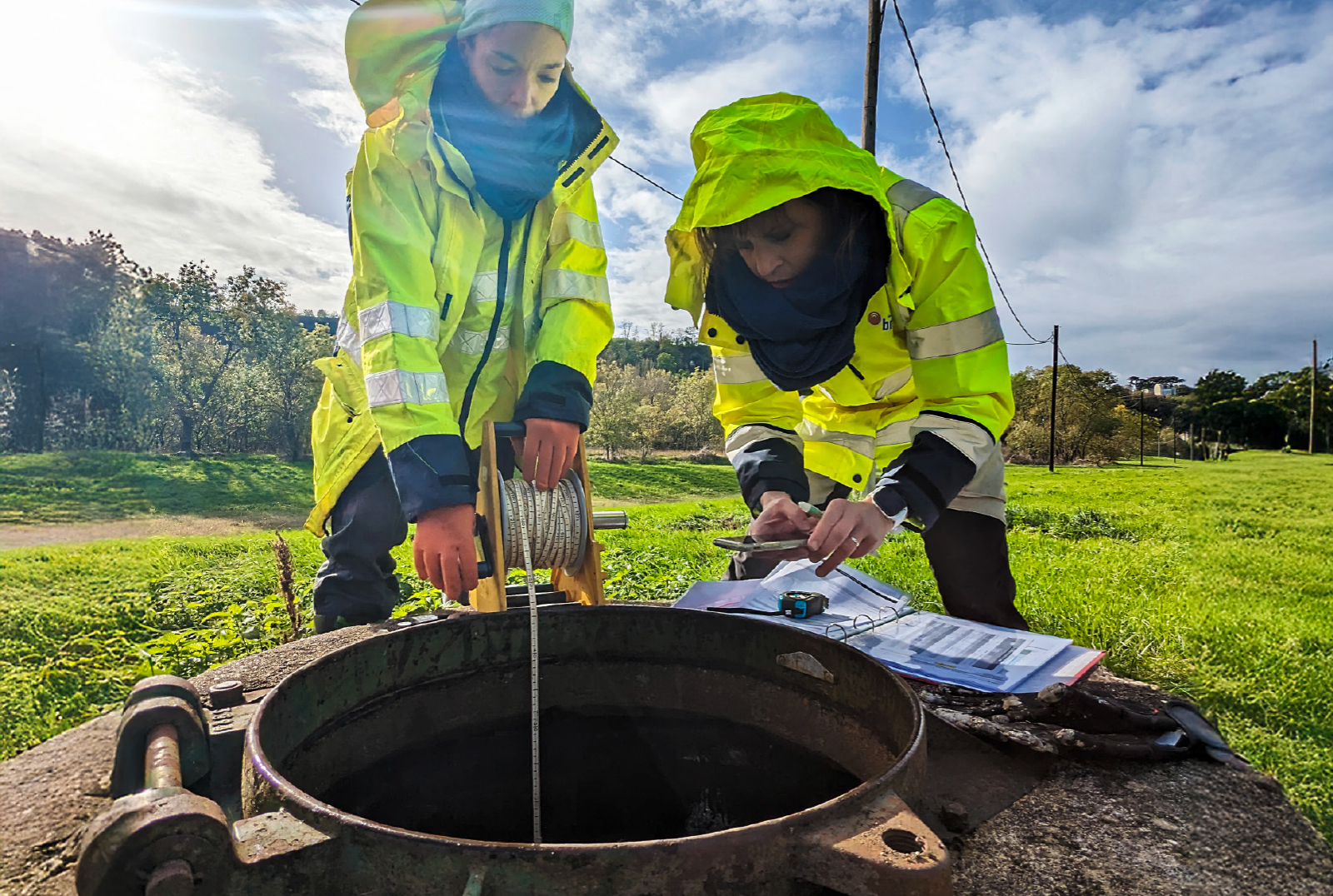
Légende
BRGM monitors groundwater levels through the national piezometric network, as seen here at Saint-Antonin-Noble-Val in the Tarn-et-Garonne department. © BRGM
Online training
“The only variable we changed in our models was the climate,” adds Sandra Lanini. “Accordingly they do not take account of the impact of human activities on groundwater levels, such as water abstraction for consumption and irrigation.” And yet these anthropogenic effects are significant in some regions and sometimes far outweigh the effect of the climate. However, this point could be taken into account if the project is allowed to continue. An addendum to Explore2 is being considered for translating these results into indicators of the state of groundwater resources under a +4°C warming scenario. “It is highly likely that new models will be developed in the future, depending on updates to the climate models,” says Jean-Pierre Vergnes.
In the meantime, the data obtained under Explore2 are available on the drias-eau.fr website. A MOOC training course developed with the project’s scientists has also been provided on the OiEau e-learning platform (e-learning.oieau.fr) to help users (catchment area committees, water agencies, local authorities and consultancies) to understand and use these hydro-climatic projections. These could pave the way on a local level for studies to accurately assess an area’s vulnerability to climate change, in order to better adapt water management policies.