Image
Légende
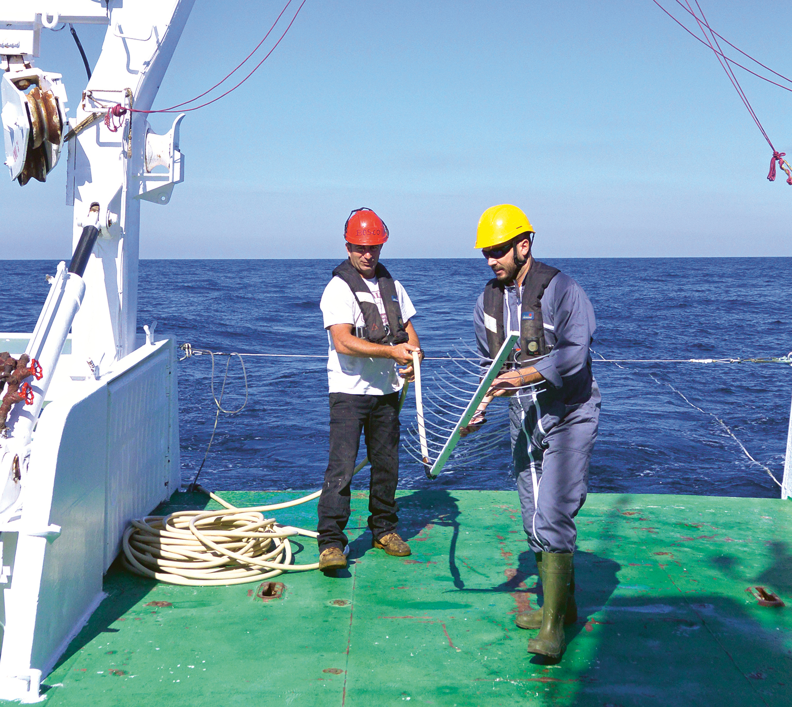
End of the acquisition of a high-resolution seismic-reflection profile. Recovery of the sparker seismic source (comb) by our team. © BRGM
Geology and knowledge of the subsurface
End of the acquisition of a high-resolution seismic-reflection profile. Recovery of the sparker seismic source (comb) by our team. © BRGM
What is the 'continental shelf'? In the morphological sense, the term refers to the geological area that extends from the coastline and out below the sea to a depth of around 200 metres. This area is concerned with various assets and activities: fishing, transport, tourism, the growing population in coastal areas, as well as with the energy transition, notably the development of marine renewable energies (MRE) and decarbonisation projects involving the geological storage of CO2, not forgetting marine aggregates for a variety of uses.
Within this context, continuously improving our geological knowledge of the continental shelf is vital for several reasons: to ensure sustainable spatial planning and limit its impact on the natural environment as much as possible, to define and manage hazards and risks (earthquakes, submersion, tsunamis, salt-water intrusion, coastal erosion) that could affect the population and infrastructures, to manage the use of material resources (e.g. beach sand replenishment) and to effectively exploit the CO2 storage or geothermal capacities of the subsurface. "Our aim is to be able to respond as effectively as possible to the growing number of questions on these issues from public authorities, industrial companies, academics and the general public, by building a knowledge base and expertise. This geological knowledge of the continental shelf and the land-sea continuum will also enable us to provide our colleagues at BRGM with data and parameters for more applied studies," explains Isabelle Thinon, a Geologist and Geophysicist.
Surveys – financed with the BRGM's own funds – are being conducted to acquire and exploit new geophysical and geological data. "We are essentially targeting areas that have not been investigated much until now, but which we suspect will be of interest in the future," says Isabelle Thinon. In recent years, surveys have therefore been conducted in certain French overseas territories (French Guiana, Mayotte) and around mainland France, notably the Bay de Seine and off the coast of Charente-Maritime. "In this area, our work identified tectonic structures (major faults, folds) and their characteristics (age of last movement, type of fault, etc.) off the Île de Ré and Île d'Oléron. It also highlighted the significant spatial heterogeneity of the bedrock geological formations." This information has been used to analyse regional land-sea seismicity and for spatial development projects.
To obtain high quality data about the maritime subsurface, the teams needed maritime equipment and facilities, high-performance tools and favourable weather conditions. The campaigns carried out at sea in recent years have, among other things, enabled the teams to acquire marine seismic-reflection data which, after processing and interpretation, provide the geometry of the subsurface formations beneath the seabed. "To test and validate the interpretations of this geophysical data, we try to sample rocks by coring or dredging, whenever possible," explains the geologist Fabien Paquet. "More often than not, we use geological records from boreholes drilled by third parties (oil companies, etc.) as part of applied studies, as well as our geological knowledge concerning the coastal land area above water." "We are interested in getting all the existing data we can to help consolidate our observations and propose geological maps that are as up-to-date and accurate as possible," adds Isabelle Thinon. For this reason, BRGM has developed many different technical and scientific partnerships with academics, research institutes, industry and government departments.
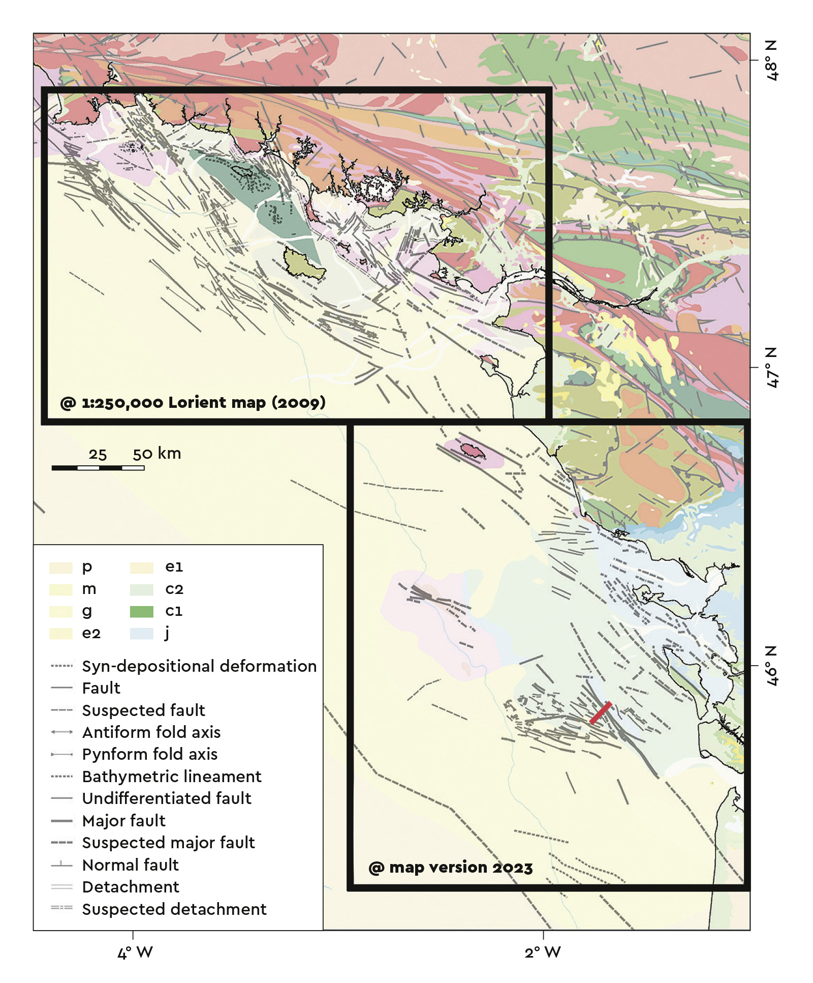
Summary map of tectonic structures (version 2023) identified on the Atlantic-seaboard continental shelf, primarily based on the interpretation of seismic-reflection profiles. The structural diagram for southern Brittany is taken from the 1:250,000 geological map (Lorient sheet) produced in 2008. The diagram concerning the area off the Charentes coast is currently being produced. © BRGM
The geological knowledge about the continental shelf is made available in the form of regional land-sea geological maps. A 1:250,000-scale geological map of Charente-Maritime is currently being produced, following on from the map of the southern Brittany shelf (Lorient sheet) published in 2008. In the same collection, the map of the Bay de Seine is being revised for publication, the map of Corsica is already available in vector format and the Golfe du Lion-Provence map is being finalised.
In recent years, BRGM has provided its geological knowledge and expertise concerning potential hazards for various purposes: upstream studies for offshore wind farms, the analysis of geothermal potential, assessing CO2 storage capacities and the seismicity of certain areas, as well as in the field of crisis management (e.g. the seismic crisis in Mayotte). In 2023, BRGM also signed two agreements with the French government under which it will contribute its geological expertise in the fields of marine renewable energies (MRE) and marine aggregates.
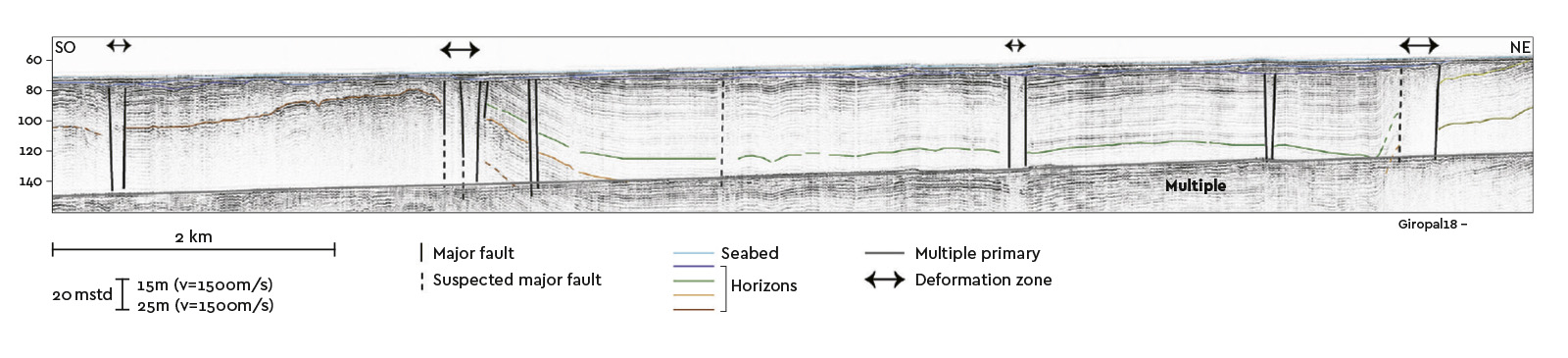
Example of a high-resolution seismic reflection profile interpretation (in time) from the GIROPAL campaign (2018, https://doi.org/10.17600/18000525), showing the architecture of the subsurface beneath the seabed of the continental shelf off the Île d'Oléron. Note the presence of major faults with apparent multi-metre vertical discharges (black lines) that displace the sedimentary cover formations on either side (coloured seismic horizons). © BRGM