Légende
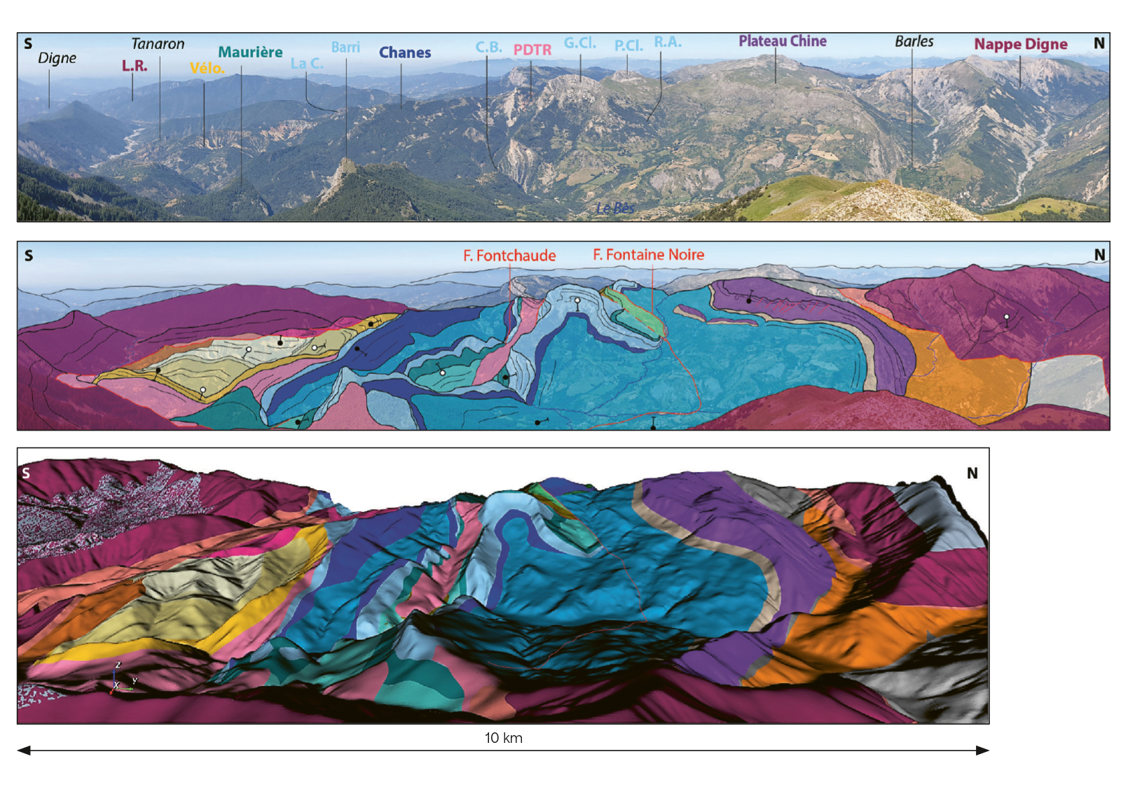
3D model of the Barles half-window and Digne aquifer, produced as part of a PhD thesis by Agathe Faure – the Alps project for the French geological reference platform and the national geological nature reserve of Haute Provence. A comparison between the geological map derived from the 3D geological model and overlaid onto the topography (bottom) and an interpretative view of the landscape (centre). © BRGM
BRGM has been working towards a national geological model for over thirty years. In 1995, it launched the GéoFrance 3D programme, followed in 2011 by the programme for the French geological reference platform (RGF) – still in use today – with the aim of making the transition from a 2D representation (the geological map) to a 3D representation of geology in France. This work paved the way for future studies while also adapting the overall approach, which is now focused more broadly on the creation of a national geoscience reference platform (RGN). “The aim is to develop a tool accessible to everybody, bringing together all the different ways of representing the subsurface across France, for a range of subject areas (water, natural hazards, etc.) and on any scale,” explains Caroline Ricordel. “As a result, this geoscience reference platform will be more than just a 3D geological model. It could even be a 4D model, taking account of changes over time.”
A concurrence of favourable circumstances is currently contributing to this endeavour. Specifically, the development of the RGN could benefit from the resources and results of two closely linked scientific programmes led by BRGM: one focusing on the improvement, representation and dissemination of geological knowledge; the other on the development of digital tools and services – drawing on the latest technologies – to be used for this purpose, with the aim of strengthening predictive capabilities.
Bringing the geoscience community together
BRGM has already modernised its modelling tools and made them interoperable. It also plans to carry out extensive work on its numerous databases in order to optimise and link them. The implementation of its integrative digital platform (PNI) will also facilitate data integration and transfers between tools.
Another key initiative in this area is the development of digital platforms supporting scientific communities in various fields (subsurface, risks, water), as part of the national research programmes (PEPR) in which BRGM is taking part. The national geoscience reference platform could be accessible via these platforms, alongside the InfoTerre portal managed by BRGM..
Further, through the RGF, BRGM has already demonstrated its ability to bring together the geoscience community, not only to pool data but also to exchange ideas on knowledge and how it is disseminated. As Simon Lopez explains, “We will continue to develop these practices in order to determine the knowledge to be disseminated and the services to be provided by the national geoscience reference platform, establishing a strategy that allows us to meet the differing needs and expectations of our three target audiences: the academic and scientific community, central government and local authorities, and civil society”.
Assessing the cost-benefit ratio
The RGN will offer data-processing based services, allowing the generation of a map or model for a specific purpose. “The challenge,” continues Simon Lopez, “is to implement a ‘living’ structure able to automatically update maps and models with the latest data and knowledge. This would be a huge breakthrough compared with the existing system.”
To develop the national geoscience reference platform, BRGM will draw on various research projects focusing on subsurface modelling, such as the RGF or METROSED. Launched in mid-2025 as part of the Subsurface PEPR programme (Digital Earth), this last project involves creating a national model of sedimentary basins by merging historical models. “This work on sedimentary basins – which cover over 70% of mainland France – will pave the way for the RGN,” says Simon Lopez.
The method for modelling the subsurface in a way that addresses multiple issues on multiple scales will be tested in the Orléans metropolitan area (Loiret region) in 2026 and could be fully deployed in operational form by 2028 across the southern part of the Paris Basin. France would then be on track to have a 3D model – like other European countries – allowing it to widely disseminate knowledge of its subsurface. The undeniable cost of this initiative is largely outweighed by the benefits, particularly in terms of risk reduction. “We plan to assess the cost-benefit ratio of geological knowledge,” says Caroline Ricordel. “The aim is to raise awareness of the need to improve and disseminate this knowledge, notably through the national geoscience reference platform.”